Study of the possible tsunamigenic seismic sources for the French coast (Atlantic facade and English Channel)
Résumé
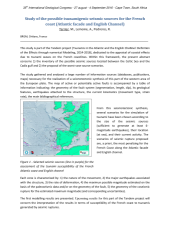
This study is part of the Tandem project (Tsunamis in the Atlantic and the English ChaNnel: Definition of the Effects through numerical Modeling, 2014-2018), dedicated to the appraisal of coastal effects due to tsunami waves on the French coastlines. Within this framework, the present abstract concerns 1) the inventory of the possible seismic sources located between the Celtic Sea and the Cadix gulf and 2) the proposal of the worst-case source scenarios. The study gathered and analysed a large number of information sources (databases, publications, maps) necessary for the realization of a seismotectonic synthesis of this part of the western area of the European plate. The map of active or potentially active faults is accompanied by a table of information indicating: the geometry of the fault system (segmentation, length, dip), its geological features, earthquakes attached to the structure, the current kinematics (movement type, strain rate), the main bibliographical references. Figure 1-Selected seismic sources (line in purple) for the assessment of the tsunami susceptibility of the French Atlantic coast and English channel
Domaines
Tectonique
Fichier principal
 35IGC_abstract_template_final_Terrier et al_Tandem-En.pdf (362.14 Ko)
Télécharger le fichier
35IGC_abstract_template_final_Terrier et al_Tandem-En.pdf (362.14 Ko)
Télécharger le fichier
Origine : Fichiers produits par l'(les) auteur(s)